DeepSARFlood-Operational SAR-based Flood Mapping using Ensemble Deep Learning and a Novel Ensemble Model Selection Algorithm
Abstract
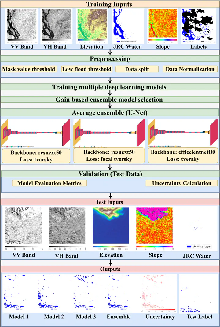
Rapid and automated mapping of flood inundation in near real-time conditions is crucial for effective mitigation of flood-related risks. While optical satellites offer valuable insights into flood extent and impact, they face limitations such as cloud obstruction, low vegetation penetration, and daytime acquisition constraints, making real-time flood mapping challenging.Synthetic Aperture Radar (SAR) satellites,however, can overcome these limitations and enable flood mapping at high spatial resolutions. In this study, we present a state-of-the-art automated flood segmentation framework based on ensemble deep learning and data fusion techniques. The framework leverages an ensemble of deep learning models trained on large-scale open-source flood data, augmented with terrain and permanent water information. To improve the ensemble generation, we introduce a novel gain algorithm based on the diversity of model outputs. Additionally, we provide uncertainties through pixel-wise probability estimates from the ensemble models. The evaluation on test data yielded an Intersection Over Union (IOU) value of 0.755 and an accuracy of 95%, demonstrating the framework’s generalizability and transferability. Notably, our proposed ensemble framework not only detects flooded regions similar to Sentinel-2 imagery, but also identifies flooded areas covered with light clouds which are missed by Sentinel-2 data. Furthermore, to aid its usage in real-time flood inundation mapping, we have implemented the model in an open source, fully automated, and parallelized python-based tool called DeepSARFlood. This tool is expected to complement upcoming SAR satellite missions such as NISAR and Sentinel 1-C for flood mapping.
Nirdesh Kumar Sharma
Doctoral student
My research interests includes Remote Sensing and Artificial Intelligence for Natural Hazards